 New Delhi: A low-pressure system in the Bay of Bengal has intensified into severe cyclonic storm Remal, the India Meteorological Department (IMD) said.
The storm is expected to make landfall on the coasts of Bangladesh and West Bengal early Sunday (May 26) morning, bringing heavy rain and strong winds.
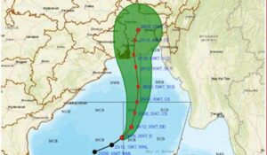
According to the IMD, Cyclone Remal will move northward and then eastward, becoming a severe cyclonic storm over the east-central Bay of Bengal by Saturday morning. It will then intensify further and track towards the coasts of Bangladesh and West Bengal, with a possibility of crossing the coast between Sagar Island (India) and Khepupara (Bangladesh) by Saturday night.
The IMD has forecast wind speeds reaching 110-120 kilometres per hour (kmph) gusting up to 135 kmph at landfall. Extremely heavy rainfall is likely in the coastal districts of West Bengal and north Odisha on May 26-27, with potentially extremely heavy precipitation in parts of northeast India on May 27-28.
A storm surge of up to 1.5 metres is forecast to inundate low-lying areas of coastal West Bengal and Bangladesh during landfall. The weather office has warned fishermen to stay out of the north Bay of Bengal until the morning of May 27.
The IMD issued a red alert for West Bengal’s coastal districts of South and North 24 Parganas, warning of heavy to very heavy rain with wind speeds reaching 80-90 kmph gusting to 100 kmph on May 26 and 27. An orange alert has been issued for Kolkata, Howrah, Nadia, and Purba Medinipur districts, forecasting heavy rain with wind speeds of 80-90 kmph gusting to 100 kmph.