


Chennai, Aug 24:
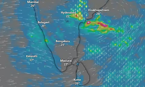
A new Low Pressure area has formed over the Northwest Bay of Bengal which was expected to bring rains to several Northern and interior districts for two days and in Western Ghat regions till August 29.
Met office said under the influence of the upper air cyclonic circulation over North Bay of Bengal off West Bengal-Bangladesh coasts, a Low-Pressure Area has formed over Northwest Bay of Bengal
and neighbourhood today, and persists over the same region.
The associated cyclonic circulation extends upto 7.6 km above mean sea level tilting southwestwards with height. An upper air cyclonic circulation lies over North Keralam and neighbourhood at 7.6 km above mean sea level.
Thr feeble trough along and off Tamil Nadu coast in the lower tropospheric level also persists.
Moderate rain at a few places with thunderstorm and lightning with gusty winds with speed reaching 40-50 kmph at one or two places is likely to occur over Chengalpattu, Chennai, Tiruvallur, Kancheepuram, Ranipet, Vellore, Tiruvannamalai, Villupuram, Kallakurichi, Cuddalore, Salem, Madurai, Tirupattur districts, Puducherry and Western Ghat districts. Light rain at a few places with thunderstorm lightning at one or two places is likely to occur over rest Tamil Nadu and Karaikal area for the next two days.
Heavy rain at isolated places with thunderstorm and lightning with gusty winds with speed reaching 40-50 kmph at one or two places is likely to occur over Nilgiris district and Ghat areas of Coimbatore district.
Light rain at isolated places with thunderstorm & lightning at one or two places is likely to occur over rest Tamil Nadu, Puducherry and Karaikal area till August 25, while Moderate rain is likely to occur over Western Ghat districts and light rain is likely to occur at isolated places over rest Tamil Nadu, Puducherry and Karaikal area from August 26 to 29.
The met office said there would be no large change with slight increasing tendency in Maximum temperatures over Interior Tamil Nadu; no large change over rest of Tamil Nadu, Puducherry and Karaikal area during day till August 27.
Maximum temperatures are likely to be above normal by 2-3 deg C at isolated pockets over Interior Tamil Nadu; near normal over rest Tamil Nadu, Puducherry and Karaikal area during Day 1 (23.08.2026) and near normal during Day 2 (24.08.2026) to Day 5 (27.08.2026)
The forecast for Chennai city and its neighbourhood is the sky conditions would be partly cloudy with moderate rain accompanied by thunderstorm and lightning likely during evening and night hours.