


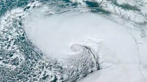
 The deep depression over the Southwest Bay of Bengal, initially predicted to strengthen into a cyclonic storm, is now expected to gradually weaken into a depression as it nears the north Tamil Nadu and Puducherry coasts.
The India Meteorological Department (IMD) has projected that the system will weaken further, bringing wind speeds of 45-55 km/hour, with gusts reaching up to 65 km/hour, during landfall.
The weather agency further said the depression, currently moving northwest, will likely cross the north Tamil Nadu-Puducherry coasts between Karaikal and Mahabalipuram, close to Puducherry, by the morning of November 30.
The depression in the Bay of Bengal is affecting the coastal regions of Tamil Nadu and Puducherry, particularly Chennai and its surrounding districts. As it moves northwest, the IMD has advised residents in these areas to remain cautious and adhere to safety protocols.
Coastal authorities in Tamil Nadu have been instructed to stay vigilant as the system approaches landfall, with measures being taken to ensure preparedness for any potential impact.
The IMD has warned of rough seas and advised fishermen to avoid venturing into the ocean. Moderate to heavy rainfall, accompanied by gusty winds, is expected across Tamil Nadu and Puducherry’s coastal areas.
Puducherry government announced the closure of all schools and colleges, including privately managed and government-aided institutions, on November 29 and 30 due to heavy rainfall forecasts linked to Cyclone Fengal.
The Indian Navy has activated a comprehensive disaster response plan in response to Cyclone Fengal’s intensification in the Bay of Bengal, which poses a significant threat to Tamil Nadu’s coastline. The Eastern Naval Command, in coordination with the Tamil Nadu and Puducherry Naval Area headquarters (HQTN&P), has implemented a strong disaster response strategy to minimise the cyclone’s potential impact, emphasising the Navy’s focus on protecting lives and property.