


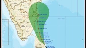
Cyclonic Storm Ditwah intensified its movement over the southwest Bay of Bengal, advancing north-northwest at 8 kmph toward India’s east coast, positioned 400 km southeast of Chennai and 300 km from Puducherry.
The storm’s speed toward land has slightly increased, prompting continued vigilance in north Tamil Nadu, Puducherry, and south Andhra Pradesh amid forecasts of landfall proximity by early November 30.
Heavy rainfall triggered by Ditwah is already battering Tamil Nadu’s Delta districts, with red alerts persisting for extreme downpours.
Ditwah, interacting with coastal areas after its Sri Lanka phase, lies roughly 400 km from Chennai and 300 km from Puducherry, gaining pace from previous 10 kmph readings.
The India Meteorological Department tracks the system heading toward the coastal stretch between north Tamil Nadu and south Andhra Pradesh, with gusty winds and rough seas affecting fishing operations.
No immediate intensification to severe cyclone status is projected, but rainfall impacts escalate.
Delta districts including Thanjavur, Tiruvarur, Nagapattinam, and Mayiladuthurai report heavy rains, aligning with IMD’s red alerts for over 20 cm in 24 hours until November 30 .