


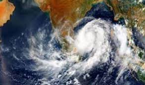
 The India Meteorological Department (IMD) in a weather warning said that a low pressure area is likely to form over the Southeast Bay of Bengal around tomorrow.
The weather department said the system will likely intensify into a depression over the central parts of south Bay of Bengal by November 24.
If a cyclone does form in the Bay of Bengal, it would be named ‘Senyar’. Submitted by the United Arab Emirates, it typically means a ‘lion’, and is the name of the next cyclonic storm in the North Indian Ocean, as per the roster.
When the fresh Low Pressure area forms over the Bay, light to moderate rain is likely to occur at many places over Coastal Tamil Nadu, at isolated places over Interior Tamil Nadu and over Puducherry and Karaikal area with thunderstorm and lightning at one or two places.
Heavy rain is likely to occur at isolated places over South coastal Ramanathapuram, Thoothukudi,
Tirunelveli, Kanyakumari districts, Cauvery delta districts of Thanjavur, Tiruvarur, Nagapattinam,
Mayiladuthurai and Pudukkottai.
These districts will continue to receive heavy rains till November 24, while heavy rain is likely to occur at isolated places over Pudukkottai, Thanjavur, Tiruvarur, Nagapattinam, Mayiladuthurai, Cuddalore and Villuppuram districts of Tamil Nadu and Puducherry and Karaikal area the next day.
On November 26, heavy rain is likely to occur at isolated places over Tiruvarur, Nagapattinam,
Mayiladuthurai, Cuddalore, and Villuppuram districts of Tamil Nadu and Puducherry and Karaikal area.
It said squally weather with wind speed reaching 40 kmph to 50 kmph and gusting up to 60 kmph is likely to prevail along and off Tamil Nadu coast, over Gulf of Mannar and
Comorin area on November 24.
Fishermen are advised not to venture into the above sea areas on that day.